Westport Infantry Barracks etc

Hospital
A detached four-bay two-storey hospital was constructed with roughcast walls during 1794, it had originally been a three-bay two-storey on a symmetrical plan. Set in grounds that was originally shared with Westport Infantry Barracks. The hospital was an interesting relic of the late eighteenth-century Westport Infantry Barracks (Accounts and Papers…Army; Navy; Ordnance 1847, 74) with the architectural value that suggested attributes as the compact rectilinear plan form that was centred on a robust doorcase & the uniform or near-uniform proportions of the openings on each floor. The building was constructed with pitched slate roof with clay ridge tiles. Coping to gables with cement rendered chimney stacks to the apexes had concrete capping to support terracotta or yellow terracotta tapered pots. Square-headed central door opening had cu- limestone threshold with drag edged dragged cut-limestone block & start surround centred on triple keystone framed timber panelled door that included an overlight. Square-headed window openings had drag edged dragged cut – limestone sills with concealed dressings. The interior ground floor included a central hall that retained timber surrounds to door openings of framed timber panelled doors with timber panelled shutters to window openings. Aspects of the composition clearly illustrated the later development or ‘improvement’ of the hospital following the sale of the complex (1901) by government authorities (Westport Estate Papers) Renovated with replacement uPVC rainwater goods on rendered cut-limestone eaves that retained cast-iron hoppers also downpipes. To accommodate continued private residential use concealed dressings framed replacement uPVC casement windows replaced six-over-six timber sash windows. The introduction of replacement fittings to most of the openings were not of beneficial impact to the character or integrity of an hospital as it formed part of a neat self-contained group alongside adjacent officers’ houses (see 31212154 – 31212157) on Prospect Avenue. Registered number is 31212153. Coordinates are 99534, 284053. (Date recorded 12th August 2008) [i]
No windows were constructed in the rear of the barracks to ensure safety of military staff from a sea attack. (Kevin Beckett) (NBC)
‘The Laurels’ at the end of Prospect Avenue (in private ownership) was the former military hospital according to this link that also provides an image: http://westportcivictrust.com/westport/town-plans
Military Houses
R. I. C. Officer’s House within the grounds of the late eighteenth century Westport Infantry Barrack originally were constructed as a terrace of four identical units (included were 31212154 – 31212156) that survived as an interesting relic (Accounts and Papers…Army; Navy; Ordnance 1847, 74) with the architectural value of the compact rectilinear plan form centred on a robust doorcase. They were five-bay single-storey residences constructed during 1794 to a rectangular plan with roughcast walls with pitched slate roof with clay ridge tiles terminated in cement rendered chimney stacks that had capping to support terracotta or yellow terracotta tapered pots. Cast-iron rainwater goods on cut-limestone eaves retained cast-iron hopper with downpipe. The square-headed central door opening had drag edged dragged cut-limestone block & start surround centred on triple keystone framing. The houses had square-headed flanked window openings with drag edged dragged cut-limestone sills with concealed dressings. The houses were sold during 1901(?) Buildings were renovated to accommodate private residential Homes. The pitched slate roof was replaced, the glazed timber panelled door with concealed dressings framed replacement uPVC casement windows, also replaced were six-over-six timber sash windows. These houses are still in situ on Prospect Avenue. Images of officer’s houses feature on this site. Registered number is 31212157. Coordinates are 99549, 284073. (Date recorded 12th August 2008) [ii]
The houses that lined one side of this lane were constructed to house officers at the military barracks. Johns Row (the oldest street in the town) had several houses built as accommodation for the barracks soldiers were originally within the present-day Elms housing estate: http://westportcivictrust.com/westport/town-plans
An Bord Pleanála overturned a decision to refuse retention for a pedestrian gate in Westport for architecture & heritage reasons that followed a ruling that the subject wall was not of historical Importance. Mr. Colm McLoughlin, inspector with An Bord Pleanála [ABP] stated that a row of four cottages, (facing the stone wall to the rear of The Elms on Prospect Avenue) were protected structures that dated from the late eighteenth century also were originally part of the Westport infantry barracks. (Anton McNulty The Mayo News 28th August 2018) [iii]
Additional Information
Unfortunately no trace exists of the Military Barracks due to demolition. Later an estate was built on the site. The area may be viewed within the Clew Bay Heritage Centre as a model of Westport Town depicts the original site at this link: https://www.westportheritage.com/
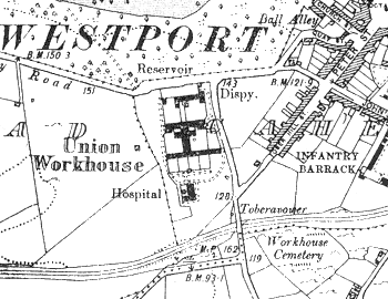
Map of Westport depicts the barracks at this link: https://digital.ucd.ie/view/ucdlib:41449
Fintan Duffy published an article in The Cathair na Mart Historical Journal 2001 no.21 (pages 14-26) titled Westport Estate & Town: an Example of Planned Settlement According to Picturesque Principles-Part 2 (page 17) he penned that on Prospect Avenue a Cul-de-Sac of terraced ‘cottages’ appeared to correspond to the frontage on the western wing of the parade ground in the barracks plan on the 1838 town map. Military Barracks was altered during the latter half of the last century prior to its demolish for housing. (Cathair na Mart Historical Journal 2001 no 21)
My parents lived at No. 2 Johns Row during the 1940’s: following renovations steps had been constructed to replace the slope: it is still occupied by residents. As a derelict house without a roof it had been in use during the above timeframe when the military horses were brought up a slope then out to the large back gardens. The house beside it (also now occupied) had an arch through which the military carriages entered then were housed. (NBC)
Footnotes
[i] Westport (https://www.buildingsofireland.ie/buildings-search/building/31212153/westport-infantry-barrack-prospect-avenue-cahernamart-westport-mayo) [Assessed 25th March 2021)
[ii] Ibid
[iii] Westport Pedestrian Gate (https://www.mayonews.ie/news/32548-westport-pedestrian-gate-to-stay-despite-heritage-concerns) [Assessed 25th March 2021)


No Comments
Add a comment about this page