Cong Dry Canal


Cong is located on the isthmus connecting Loughs Corrib and Mask, near the towns of Headford & Ballinrobe, also the villages of Clonbur, the Neale & Cross. Cong is known for its underground streams that connect Lough Corrib with Lough Mask to the north. [i]
An ill-fated Cong canal begun during 1848 was abandoned in 1856 under the drainage (Ireland) Act 1846. [ii]
Famine Relief Works
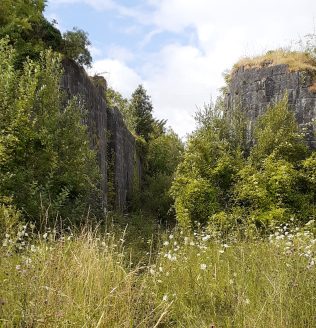
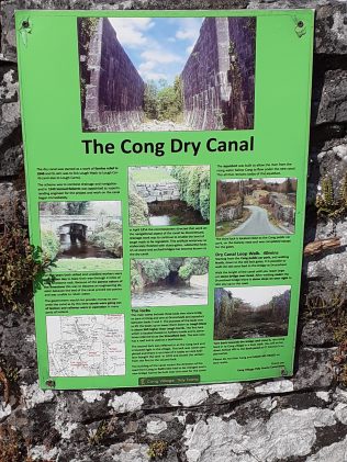
A four mile long dry canal was built as a work of famine relief in 1845. The project had in aim to link Lough Mask & Lough Corrib with Lough Carra. Mr. Alexander Nimmo was the main engineer. The limestone work was blasted through but it was discovered that the water disappeared into the ground due to the nature of the terrain. The government failed to provide money to concrete the canal with the result the project was abandoned. Three locks along the canal were built because of the thirty-six feet ascent between the two lakes several bridges were also built over the canal such as Drumshiel Bridge. [iii]
The Cong Canal was built over five years by the Commissioners of Public Works between 1848 & 1854 as a combined scheme to provide navigation, drainage also mill-power. In 1854 the Commissioners abandoned the navigation aspect of the scheme. Samuel Roberts their engineer was instructed ‘to suspend the execution of all navigation works in this division of the district, and complete only such as were necessary for the regulation of the waters of Lough Mask, for drainage purposes.’ Known as the ‘Dry Canal’ the water level can vary depending on the time of year between zero & 3.5 meters (summer dry, winter full) It is five kilometres in length. Features of the canal remain as a tragic testimony to Ireland’s Famine. [iv]
Further Information
Brief history of Cong Canal archived from the original on 12th March 2007, retrieved 1st August 2005.
McKnight Hugh 1987 The Shell Book of Inland Waterways David & Charles (page 31)
Semple Maurice 1981 By the Corribside (self-published)
Board of Public Works (1855) Twenty-third Report from the Board of Public Works, Ireland: with appendices 1854 HMSO.
The village of Cong is in County Mayo close to the shores of Loch Corrib. The Pigeon Hole Ballymaglancy cave has stalactites also stalagmites. Nearby are numerous caves that are historically & geologically significant i.e. Captain Webbs Cave, Kelly’s Cave, Lady’s Buttery also Horses Discovery caves in the vicinity of Cong town. The Giant’s Grave cave near Cong was a megalithic burial chamber. Caves of Cong/Kong or known as ‘The Red Haired Man’s Wife’ Belfast collector Edward Bunting (1773-1843) printed a version of the tune; very similar to O’Neill’s setting save for the transposition. Printed sources: Bunting (Ancient Music of Ireland) 1840 no. 83, page 63. O’Neill Music of Ireland: 1850 Melodies 1903 no. 161 (page 28) Recorded sources: JNBS001, Brian Stafford & Josie Nugent The Caves of Cong 2014 (6th May 2019): https://tunearch.org/wiki/Annotation:Caves_of_Cong_(The)
A special hidden cave known as Pigeon Hole Cave is referenced at this site:
https://www.muddysoulsadventures.com/blank-page-20
Footnotes
[i] Points of Interest (https://www.mayo-ireland.ie/en/towns-villages/cong/visitors-guide/points-of-interest-around-cong.html) [Accessed 12th March 2022]
[ii] Drumsheel Upper (https://www.buildingsofireland.ie/buildings-search/building/31216002/drumsheel-upper-county-mayo) [Accessed 11th March 2022]
[iii] Ibid
[iv] Cong (https://en.wikipedia.org/wiki/Cong,_County_Mayo) [Accessed 12th March 2022]


No Comments
Add a comment about this page